
The 2023 Turkish earthquakes triggered dozens of mud volcanoes within a thousand kilometers.

The earthquakes that shook southeastern Turkey in February 2023 , in addition to causing thousands of deaths, activated dozens of volcanoes more than 1,000 kilometers away. These were not classic lava eruptions, but mud eruptions. The phenomenon, although rare, usually occurs in areas with fluids beneath the Earth's surface. In parallel and related, a group of seismologists shows in the scientific journal Science how several faults near the Caspian Sea silently shifted. Never before had an earthquake been recorded that could have such impacts at such a distance.
Six minutes after the earth split on the Turkish-Syrian border in the early hours of February 6, the earthquake's surface waves reached the shores of the Caspian Sea, more than 1,000 kilometers from the epicenter. A study of ground changes detected by radars from the Sentinel-1 satellite constellation, seismographs, and other geodetic sensors confirmed how much of the terminal basin of the Kura River, the eighth largest in Europe and which flows into the Caspian, registered the impact of the earthquakes.
The authors of this study have confirmed two parallel and possibly connected phenomena. They identified up to seven faults in the ground that moved "silently" prior to the earthquakes. By "silently," Cécile Doubre, a researcher at the University of Strasbourg (France) and co-author of the study, means that "the fault slips without emitting seismic waves." The impact was only a few millimeters, but the affected area is enormous. In these seismic movements, the ground moves very little, slowly, and without rupture, so it doesn't release the sudden energy that usually causes disasters.
“If the slip had been seismic, it would have been magnitude 6 [the first quake in Turkey, Pazarcik, had a magnitude of 7.8]; it is the largest known fault slip [at a distance] to date,” Doubre maintains. The Kura River basin and the entire region surrounding the Caspian are very far from the devilish zone where the earthquakes occurred: the area where the Anatolian tectonic plates meet the Eurasian, Arabian, and African plates. And yet, it was there that the largest external manifestations of the earthquakes (beyond the epicenter itself) occurred in the form of new mud volcanoes.
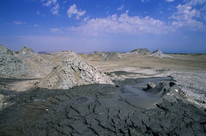
The region where the faults moved silently belongs administratively to Azerbaijan. There are at least 400 extinct or dormant mud volcanoes there, both on land and underwater. That day, 56 of them awoke, and new ones were formed. Although they are not the same as lava volcanoes, they have many similarities. Like Etna or Cumbre Vieja , their eruptions can be effusive or explosive. The materials they eject are varied, generally in a gaseous and fluid state, in the form of low-viscosity sediment fluids (see photo above). The main ingredient of these muds are clays and other deep rock fragments, but they also contain hydrocarbons (petroleum) and gases such as methane. Among those activated by the earthquakes, some are small, with an area of about 500 m², but others are formations observable from space, with a base of up to 500 km². According to the authors, it is one of the most distant earthquake responses documented.
"We believe that Alexander the Great's expedition also encountered some of these mud volcanoes," says Juan Ignacio Soto, professor of Internal Geodynamics at the University of Granada. "Azerbaijan was known as the land of fire, due to the gases they emitted and burned. Marco Polo and other travelers of the 16th and 17th centuries also recorded them in their writings, but it wasn't until the 19th century that Russian scientists sent by the Tsars began to study them." In fact, "Soviet scientists were the first to offer a scientific explanation for the connection between volcanoes and mud diapirs," he adds.
Soto is finishing a book on mud volcanoes and "the associated diapirs," he adds. The latter are the most immediate causes of outflow and could be compared to the magma that feeds lava volcanoes. "A diapir is a structure within the Earth's crust, beneath the surface, in which fluid rocks can rise, breaking and perforating those above. And the volcano would be the surface emission," explains the professor, who is also a research associate at the Bureau of Economic Geology at the University of Texas at Austin (United States), where he has spent the last few years studying these phenomena.
The professor admits to comparing diapirs to a sponge. "We believe there are two processes that allow mud diapirs to form, and then mud volcanoes." In one, the area would be subjected to compression, and "under this compressive stress, the fluids within the sediments increase in pressure, allowing the rocks to break, behaving like a fluid and giving rise to a volcano on their surface." It's as if by pressing the sponge, the fluids within the pores increase the pressure until they exceed a critical point, at which point the sponge (the rock, in this case) becomes a fluid.
But so little is known about them that Soto also suggests another mechanism: "The existence of hydrocarbons and their transformations also favor these processes because hydrocarbons can [pass] into a gaseous phase, especially methane, which increases in volume as it rises, breaking rocks, allowing fluids to escape violently until they emerge in mud volcanoes," he explains. Azerbaijan's subsoil houses one of the largest hydrocarbon deposits on the planet. In particular, the Kura Basin and the South Caspian Sea rest on thick, soft sediments, which can behave like fluids. Seismic waves from Turkey would have been enough to trigger a kind of chain reaction, even if it started more than a thousand kilometers away.
EL PAÍS
%3Aformat(jpg)%3Aquality(99)%3Awatermark(f.elconfidencial.com%2Ffile%2Fa73%2Ff85%2Fd17%2Fa73f85d17f0b2300eddff0d114d4ab10.png%2C0%2C275%2C1)%2Ff.elconfidencial.com%2Foriginal%2F6e6%2F665%2Faf0%2F6e6665af06d7d19aa93cfbafc75476a5.jpg&w=1280&q=100)
%3Aformat(png)%3Aquality(99)%3Awatermark(f.elconfidencial.com%2Ffile%2Fa73%2Ff85%2Fd17%2Fa73f85d17f0b2300eddff0d114d4ab10.png%2C0%2C275%2C1)%2Ff.elconfidencial.com%2Foriginal%2Fdfc%2F122%2Fca4%2Fdfc122ca440ff48d3f04b61e22870d86.png&w=1280&q=100)
%3Aformat(png)%3Aquality(99)%3Awatermark(f.elconfidencial.com%2Ffile%2Fa73%2Ff85%2Fd17%2Fa73f85d17f0b2300eddff0d114d4ab10.png%2C0%2C275%2C1)%2Ff.elconfidencial.com%2Foriginal%2F0c4%2Fa48%2Fdb1%2F0c4a48db105bbd4f3b91a7b00922c665.png&w=1280&q=100)

